The Madeira waterway is one of the most important transport routes within the Amazon Forest, known as the Northern Logistics Corridor. It is also the second most significant waterway in the North, second only to the Amazon waterway, of which it is a major right-bank tributary.
The waterway supports the navigation of large convoys, with capacities of up to 18,000 tons, even during drought periods. Its width ranges from 440 meters to 9,900 meters, and its depth fluctuates with the dry and rainy seasons, reaching up to 13 meters.
However, the Madeira River is experiencing severe effects from the climate crisis, with a drastic reduction in its volume and the formation of large sandbanks that obstruct the passage of cargo and passenger vessels.
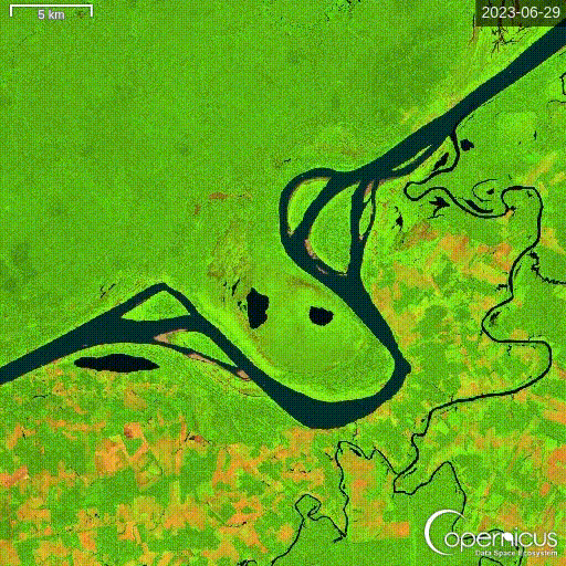
I created an animation using images from the Sentinel-2 L2A satellite, visualizing a section of the Madeira River near the Cuniã Ecological Reserve, close to the grain port of Porto Velho/RO.
The animation uses the Agriculture Theme (False Color Bands 11, 8, 2) to enhance the visualization of sandbank formations along the riverbed during the most severe drought in the past year (06/29/2023 to 10/11/2024). The riverbed is highlighted in dark blue, while the sandbanks contrast in beige.
If you are a student of remote sensing or would like to explore the platform, access the link to view the region on the Copernicus Browser [1].
DOI: https://doi.org/10.5281/zenodo.15272102
#ClimateCrises
Citation
Torres do Amaral, C. (2025). Drought of the Madeira River. In Amazontech: Revista de Estudos Interdisciplinares (Vol. 7, Número 1). DOI: https://doi.org/10.5281/zenodo.15272102